|
For our annual Easter hike we invited our friend Peter to drive down to Copper Canyon with us. We knew it was a gamble trying to get three people into the bench seat of Cathy's little Mazda truck. Not that the truck wouldn't make it. We were more worried that the three of us wouldn't survive the 14 hour trip down without killing one another. Cathy was a good sport and sat in the middle the whole way, including the last 22 kilometers of bouncy rocky rutted track. We arrived at our destination late in the afternoon, and noticed that the remote Hotel Tejeban was totally empty. There were no cars. Nobody was milling about. No telltale wisps of smoke from a chimney. We poked around a few minutes, and I went through a gate toward what looked like a lobby or a restaurant. Just a few feet from the gate, the earth began to shake. I turned around to see two big Rottweilers coming after me. It was too far to the gate, so I raised my arms like the Mexicans do when they're getting ready to throw a rock, and the critters broke out of their run. Just at that moment a guy appeared and called them off. Good thing too, because even if I'd had a rock I wouldn't have lasted too long with those bloodthirsty beasts. It was then that we noticed the shack with some laundry hanging about. Cathy and Peter were on the other side of the gate enjoying the show. A couple followed the guy out, and we all laughed, made our introductions, shook hands, and talked a bit. We had hoped to leave the truck in the care of the hotel management during our upcoming hike, but with no guests or management on site, at least the caretakers were here.
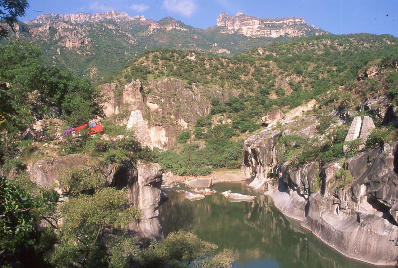
We asked if we might have something to drink or some food before we started. We kind of wanted to check things out before we made our request. They invited us into the restaurant. We'd heard of course of narco-architecture. That's the kind of building done in really poor regions that is totally over the top, without regard to cost or style. Here was a stupendous example. This huge room must have been 100 feet across, without any walls except for the frames for the floor-to-ceiling windows, offering a stupendous 360-degree view. It was cantilevered over the canyon edge to give you the effect of being suspended in space. The chimney from the central fireplace supported the ceiling girders about 20 feet above. The round fireplace must have been 8 feet across. Wow!
All the electricity was off, so we opted for a warm beer. It seemed more palatable than a warm soda. The three of us were on one side of the bar, and the three of them were on the other side looking at us and wondering what the hell three gringos were doing here talking about going down the canyon for a week. The room was filled with dining tables, chairs, and couches for an intimate conversation after dinner, but it looked abandoned. We chatted and sipped our warm beers quietly in the still air. The conversation was waning and the sun was getting lower. The three of us were a bit ratty after being on the road for two days. We were dirty and stinky and hadn't changed clothes recently. We mentioned how nice it would be to bathe in the river. Our host, who was a really nice guy, had a smile like he'd been hit with a brick and had all his teeth knocked out, managed to catch them, and put them back in; and that higgledy piggledy arrangement was the way they had grown. He had a big smile but it was a bit misshapen. We paid up, and thanked them profusely. As he turned, he saw his face in the mirror, and uttered "God, I'm ugly!" We all laughed, but it was weird that he had this revelation at just that moment.
 |
The next morning we started down. We hadn't realized just how far it was to the river. The only real preparation we had made was to look at the map to figure out our route, without paying strict attention to the number of topo lines between point A and point B. So down and down we went. The main focus of this hike was that Tejeban, or more properly the canyon below it, is the actual Barranca del Cobre. Never mind that the region for a hundred square miles is now called barranca del cobre, or copper canyon. This was the epicenter and namesake of the Copper Canyon. Like the Colorado River that goes through Grand Canyon, Marble Canyon, Desolation Canyon, Glen Canyon and lots of others, the Urique River has its narrows and its wide settled places. This Copper Canyon is known for silver, and lots of it. There used to be regular mule trains. As the infrastructure developed, mules with specially made saddles used to carry two 75 pound ingots each, with up to 100 mules in a train. They had safe, protected ranchos roughly a day apart. Originally they went to the coast in Sinaloa, but the infrastructure developed towards Chihuahua, and that's where they headed; thanks in no small measure to Alexander G. Sheppard, the former Governor of Washington, D.C. He had bought interests in the Batopilas mining district. As Governor of D.C., he had made great improvements in water and sewer systems, sidewalks, streetlights, and streetcars. Some of his friends had ridden his coattails and done pretty well for themselves. As these things happen, he retired under a cloud of controversy, but he used that vitality and mentality to make things happen in Batopilas, too. He installed a hydro electric plant at the end of a six mile canal. Part of that system was used to produced electricity into the 1970's, even though mining operations stopped on the grand scale during the Mexican Revolution. Thanks to him, Batopilas was the second city in Mexico to have electricity.
 |
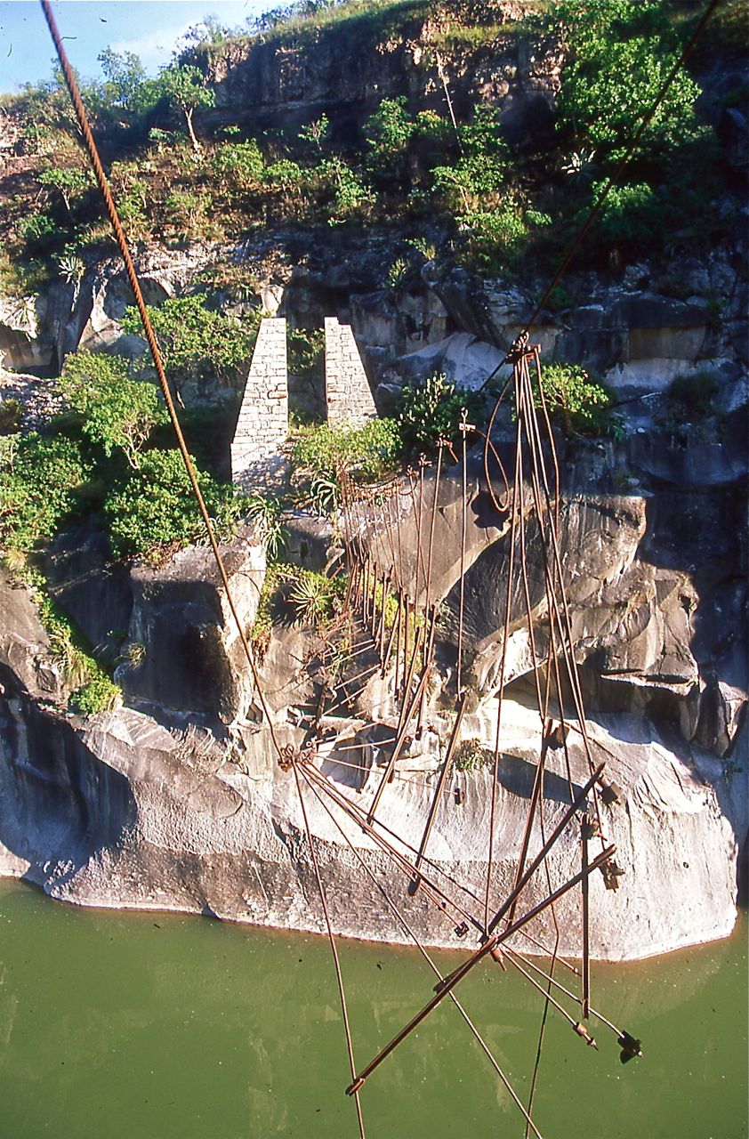
The cart was on a high landing. We noticed there was a grove of orange trees, and another of avocado trees. It seemed like a pretty clean little rancho that the owners had for themselves. There was a little side drainage flowing, and a few arrastras for grinding gold ore. In a little niche in the wall we saw a pair of rubber gloves sticking out of a wooden box, with a bellows attached. I guess this was some kind of contraption to smelt nuggets from gold dust. A little further on was evidence that children had been playing but we didn't see anybody about so we continued on downstream. The trail gave out and we had to start boulder hopping. And we pretty much had to keep boulder hopping for two more days!
Shortly after breakfast the following day, we came to a side drainage running pretty good. According to the map, this was the Cusarare, our next target point on our little hike. At the confluence was a huge boulder, bigger than a bus, with a little rock room built on top, smaller than a doghouse. On top of the doghouse was a huge prickly pear cactus. There wasn't an easy way up, but by using his fingers in the pockmarked rock, Peter scaled it. He hauled us up to investigate. It must have been a sentry post, with clear views up and down the river.
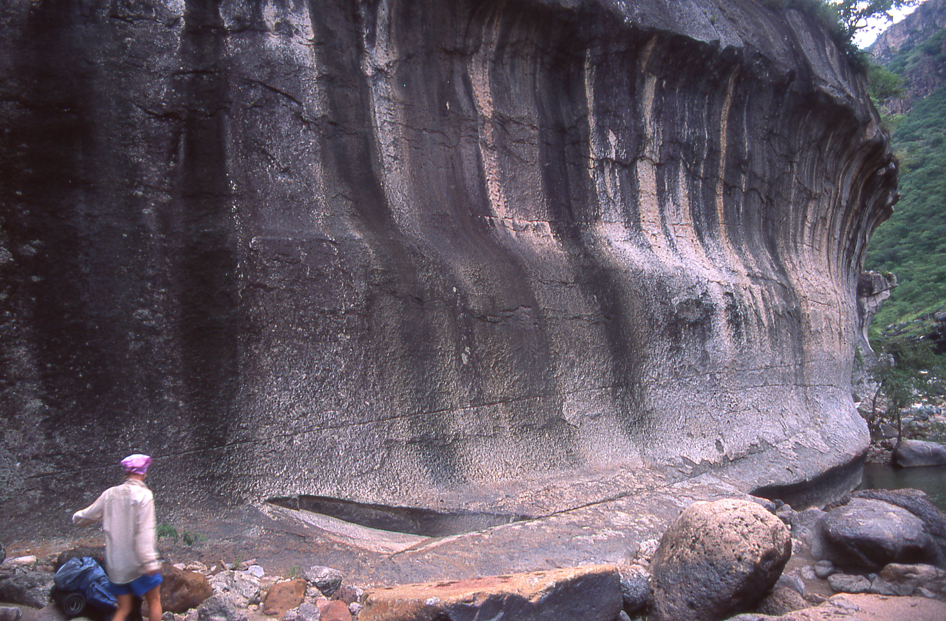
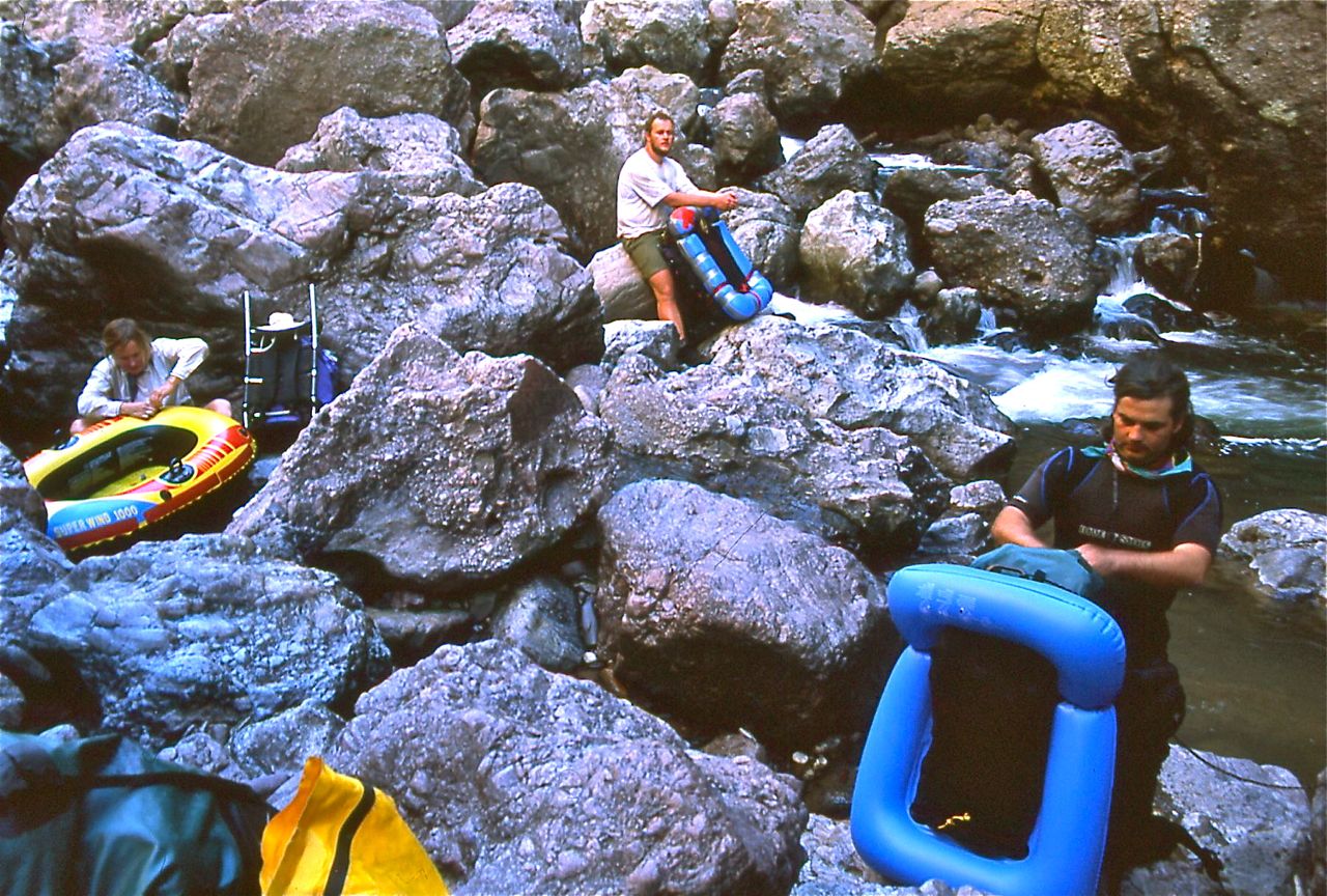
We bid adios to the Urique and started upstream in the little arroyo. It wasn't too long before we got stoppered! We were in a pool, with a waterfall created by three big, round boulders. We all swam the edges and tried to find a handhold or a log, or a rabbithole under the rocks, or a vine to pull ourselves over the rocks but they were too big and slippery. We had to leave the creek and take the land route.
 |
We got to the top of that obstacle, and found ourselves in somebody's field. They had seen us, or heard all the noise we were making. Peter was in the lead and said, "What should I do?" We really couldn't do anything, but wave, "Buenas dias!" There was Grandma, the grandkids and some adults, hanging out at a cave. We had just entered their well irrigated pot field. They waved back, and we started chattering about how we were just following the trail, and does it go to so-and-so, and how pretty the crop looked and all. They were obviously proud of their plants but it wasn't corn so you couldn't eat it or turn it into tesguino. It had started sprinkling on the scree field. It was raining pretty good by now, so we confirmed we were on the right trail, and asked if there was a dry place to camp nearby. They said that yes, we could run the cows out of their overhang down the trail a bit, and we would be able to stay dry there. It was raining harder as we politely thanked them and moved on. Thankfully, the ruin was close by, and the cows had already moved to dryer ground. The floor was thickly carpeted with cowpies. This is "Home, Sweet Home" to assassin beetles, and we saw a few as we rearranged things for the night.
In the morning it was still cloudy from all the rain. We made a slow start, enjoying a second cup of coffee in the cool mist. The trail in front of our camp cozy campsite in the ruin below the overhang climbed steeply. As the clouds melted, we slung our packs and started up. We were just admiring the view when a guy came running down the trail carrying a heavy bag of something, and smoking a cigarette. Then another guy came running past carrying a half a case of eggs wrapped in twine. Looking around we saw one of the young guys from the field yesterday sitting back on a rock smoking a cigarette. He said that we had just missed the truck. We were somewhat befuddled, not knowing what he was talking about, but by now we were to the top of the climb. Sure enough, there was a road. Some other people were milling about the muddy rut of a road, packing up their stuff, and disappearing into the woods. This truck must have brought in a lot of stuff. Where the road came from and where it went, we wouldn't have the luxury of finding out, because we were navigating from a map. If the roads and trails are marked at all, they're wildly inaccurate. Later this same trip we encountered a trail on the map. It was actually a dryfall- a smooth dry, vertical trail. Maybe the whole place was mapped from a satellite photo. On Mexican 1:50,000 topo maps, the ridges are generally accurate as are the rivers, although the topo lines vary greatly. In fact, on the map of Picacho del Diablo, the tallest point in Baja, the peak is unnamed, and the second highest point is given the distinction of being Picacho del Diablo. Our ambitious hike consisted merely of making a seven day loop, come what may.
We followed the mud track a ways, and then diverted to follow a great burro trail worn white on the gray volcanic rock. It headed the canyon, and kept going our way. It started to rain again, and slowed our progress. If we had lived here we might have known that when the trail veered one way, and the compass hinted that we should go to the other, it was heading another, smaller canyon- one that we didn't know about until it was too late. Although is was only 60 feet or so, it was too steep, and the rock was too wet and rotten to attempt to down climb, so we had to follow the rim. By the time we headed it, another day had passed. It was time to set up camp.
 |
We started on our way. The sun had been out all day, but the soggy route brought us to numerous wet crossings. The water was still running brown. The sand and gravel washed across the trails confirmed what a fierce rain it had been. Another steep ascent, and we finally hit the road between the highway and Hotel Tejeban. A quick check of the map with the sun getting low in the west, kind-of confirmed that we were only 7 kilometers from the truck. Changing into dry socks for the easy walk back, we smiled to each other. A satisfying warm beer was only an hour away!